
-9%
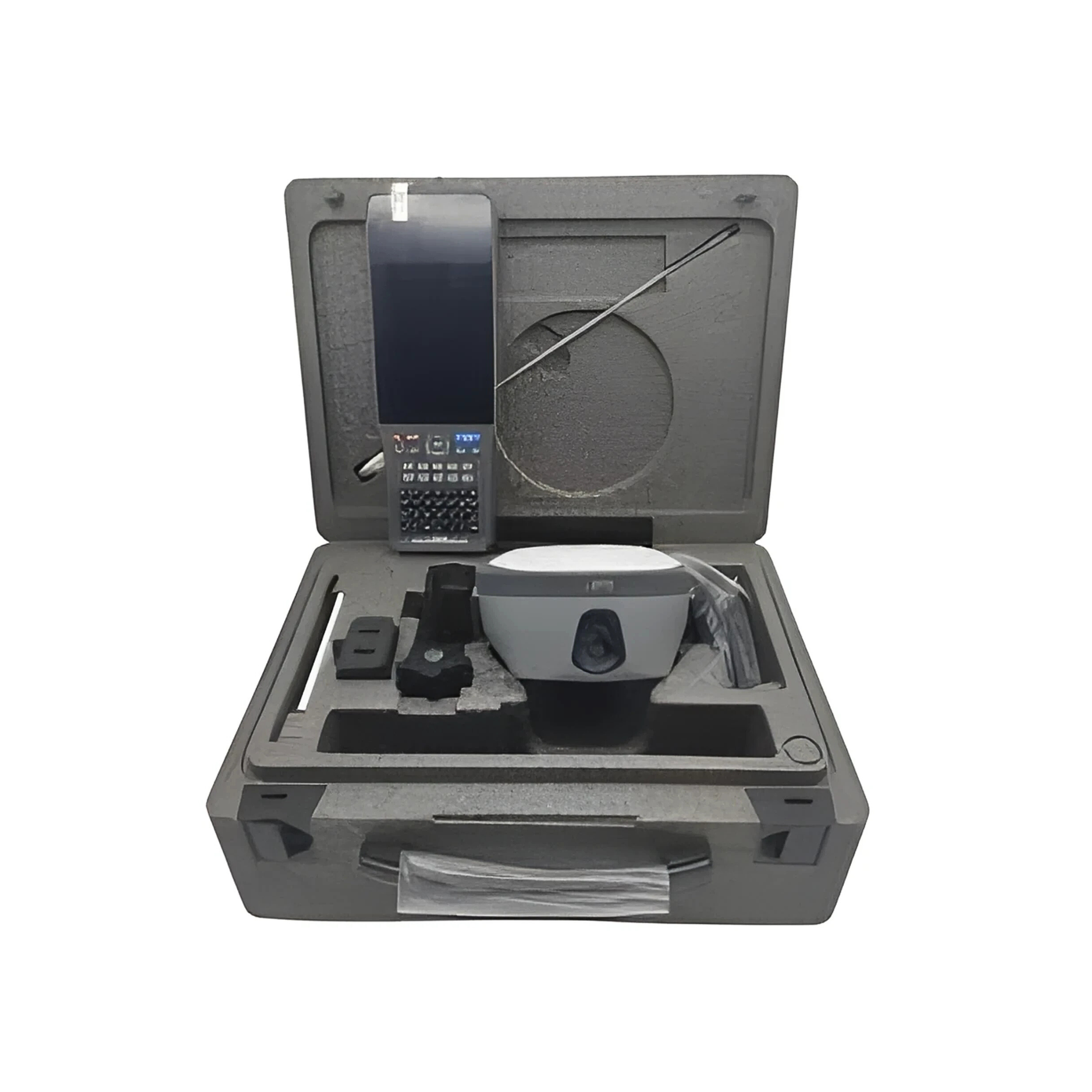


MERIDIAN GPS M20
Original price was: د.إ245.00.د.إ222.00Current price is: د.إ222.00.

TRIMBLE R8S GPS
Original price was: د.إ245.00.د.إ222.00Current price is: د.إ222.00.
HI TARGET GPS VRTK2
Original price was: د.إ245.00.د.إ222.00Current price is: د.إ222.00.
- Dual Cameras: Enables image-based surveying and live visual stakeout for rodless measurements.
- Tilt Compensation: High-precision IMU with auto attitude correction; accurate even when tilted up to 30°.
- RTK Accuracy:
- Horizontal: ±(8 + 1 ppm) mm
- Vertical: ±(15 + 1 ppm) mm
- Fast Initialization: RTK fix in under 10 seconds with >99.99% reliability.
- Built-in UHF Radio: Adjustable power (0.5W/1W/2W) for flexible base-rover setups.
- Smart Connectivity: 4G LTE, Wi-Fi, Bluetooth 4.2, USB Type-C, and NFC.
- Internal Storage: 8GB memory supporting GNS and RINEX formats.
- Rugged & Lightweight: IP68-rated, drop-resistant up to 2m, weighs ≤0.82 kg.
- Long Battery Life: 6800mAh battery provides over 10 hours of field operation.
- Smart Features: WebUI, voice prompts, remote cloud services, and smart base station support.
- Wide Operating Range: Functions reliably from -30°C to +70°C.
Description
Description
Hi-Target vRTK2 GNSS RTK Receiver
The Hi-Target vRTK2 is a next-generation visual RTK GNSS receiver that integrates advanced positioning technology with dual-camera imaging, tilt compensation, and smart connectivity. Designed for high-precision land surveying, construction, and geospatial applications, the vRTK2 offers a powerful combination of accuracy, efficiency, and ease of use.
🔹 Key Features
- 1408 GNSS Channels: Supports GPS, GLONASS, BeiDou, Galileo, QZSS, IRNSS, and SBAS for full-constellation tracking.
- Dual Cameras: Enables non-contact image surveying and Live View Stakeout, ideal for hard-to-reach or hazardous environments.
- Tilt Surveying: Built-in high-precision IMU with auto attitude compensation; accuracy of 8mm + 0.7mm/° tilt (within 30° < 2.5cm).
- RTK Accuracy:
- Horizontal: ±(8 + 1 ppm) mm
- Vertical: ±(15 + 1 ppm) mm
- Static Accuracy:
- Horizontal: ±(2.5 + 0.5 ppm) mm
- Vertical: ±(5 + 0.5 ppm) mm
- Fast Initialization: <10 seconds with >99.99% reliability.
- Data Storage: 8GB internal memory, supports GNS and RINEX formats.
- Connectivity:
- 4G LTE, Wi-Fi (802.11 a/b/g/n), Bluetooth 4.2/2.1+EDR
- USB Type-C, SMA interface, Nano SIM slot
- Built-in UHF radio (410–470 MHz, 0.5W/1W/2W adjustable)
- Smart Features: NFC, OTG, WebUI, smart base station, voice prompts, remote cloud services.
- Battery Life: 6800mAh lithium battery, over 10 hours of operation.
Reviews (0)
Brands


Related products


GPS HI TARGET V300/VRTK2
- GNSS Channels: 1400+ for enhanced signal tracking and reliability
- Satellite Support: Compatible with 50+ satellite systems including GPS, GLONASS, Galileo, BeiDou, and more
- Positioning Accuracy: High-precision RTK and static measurements (exact values depend on model)
- Battery Life: Long-lasting battery for extended field operations
- Connectivity: Supports USB, Bluetooth, and wireless data transfer
- Design: Rugged, weather-resistant casing for tough job site conditions
- Data Storage: Internal memory with support for external storage options
- User Interface: Intuitive controls and display for easy operation
- Software Compatibility: Works with major surveying and GIS software platforms
- Startup Time: Fast satellite acquisition and fix times for efficient workflow


LEICA AUTO LEVEL
- High-Precision Optics: Delivers sharp, clear images for accurate readings over long distances.
- Automatic Compensator: Maintains a stable line of sight by correcting for slight tilts, ensuring consistent accuracy.
- Easy Focusing: Smooth and responsive focusing knobs for quick target acquisition.
- Sturdy Base: Equipped with three leveling screws for secure and stable setup.
- Built-In Bubble Level: Assists in precise leveling during instrument setup.
- Durable Construction: Rugged housing designed to withstand tough job site conditions.
- Compact & Portable: Lightweight design for easy transport and setup.


LEICA BUILDER SERIES TOTAL STATION
- High Measurement Accuracy: Delivers precise angle and distance readings for reliable construction layout.
- Reflectorless Measurement: Allows distance measurement without a prism, ideal for hard-to-reach or unsafe locations.
- User-Friendly Interface: Intuitive controls and clear display for easy operation, even by non-surveyors.
- Rugged Construction: Weather-resistant and durable design suitable for tough job site conditions.
- Versatile Functionality: Supports layout, alignment, volume calculation, and basic surveying tasks.
- USB & Bluetooth Connectivity: Enables fast and secure data transfer to external devices and software.
- Long Battery Life: Rechargeable batteries designed for extended field use.

MERIDIAN GPS M20
- Green Laser Technology: Integrated laser with a 100-meter range for rodless, visual alignment in challenging environments like riverbanks, bridges, and indoor-outdoor transitions.
- IMU Tilt Compensation: 120° calibration-free IMU allows for fast, accurate data collection without leveling the pole.
- Long-Distance Capability: GSM mode supports communication up to 45–50 km, with an effective working radius of 15 km, ideal for large-scale surveying projects.
- Compact & Rugged Design: Palm-sized (699g), IP67-rated for dust and water resistance, suitable for harsh field conditions.
- Extended Battery Life: Equipped with a 7.4V 7000mAh lithium-ion battery, offering up to 26 hours of continuous operation.
- Connectivity: Bluetooth, 4G, and GSM for seamless data transfer and remote operation.
- Applications: Perfect for topographic mapping, construction site alignment, precision agriculture, municipal surveying, and infrastructure monitoring.


NIKON TOTAL STATION
- Measurement Range: Long-range EDM for precise distance readings
- Angle Accuracy: High-precision angular measurements (model-dependent)
- Battery Life: Extended operation for full-day fieldwork
- Data Storage: Internal memory with support for external data transfer
- Connectivity: USB port for fast and secure data exchange
- User Interface: Intuitive menu system with easy-to-navigate controls
- Build Quality: Rugged and weather-resistant design for tough environments
- Applications: Suitable for topographic surveys, construction layout, and monitoring
- Optical System: Nikon’s advanced optics for clear and accurate targeting
- Display: High-resolution screen for clear data visualization


SOKKIA DIGITAL AUTO LEVEL
- Digital Display: Offers clear, easy-to-read measurements, reducing human error and improving speed.
- Automatic Leveling: Built-in compensator ensures quick setup and consistent accuracy even on uneven surfaces.
- User-Friendly Controls: Simple interface with intuitive buttons for fast operation.
- High Accuracy: Delivers precise leveling results essential for critical construction and surveying tasks.
- Durable Build: Rugged design built to withstand tough job site environments.
- Compact & Portable: Lightweight and easy to carry, ideal for mobile fieldwork.
- Reliable Performance: Consistent results across various environmental conditions


SOKKIA IM SERIES TOTAL STATION
- Advanced Angle Measurement System: High-accuracy angular readings with minimal error for precise layout and alignment.
- Reflectorless EDM: Measures distances up to 800 meters without a prism, ideal for inaccessible or hazardous locations.
- Bluetooth® Connectivity: Integrated wireless communication for connecting with data collectors and other devices.
- Rugged & Weather-Resistant Design: Built to endure tough field conditions with dust and water resistance.
- User-Friendly Interface: Intuitive graphical display and keypad for easy navigation and data input.
- Long Battery Life: Extended operational time for uninterrupted fieldwork.
- Fast and Reliable Data Collection: Quick setup and measurement speeds to boost productivity.
- Compact and Lightweight: Easy to transport and set up on-site.

TRIMBLE R8S GPS
- Multi-Constellation GPS Tracking: Supports GPS, GLONASS, Galileo, BeiDou, and QZSS for enhanced satellite coverage and reliability.
- Scalable Configuration Options: Allows users to purchase only the features they need and upgrade later as requirements grow.
- Centimeter-Level RTK Accuracy: Delivers high-precision positioning for demanding survey tasks.
- Integrated UHF Radio: Enables base-rover communication without external radios.
- Internal Cellular Modem (Optional): Supports real-time corrections via internet-based services.
- Trimble Access Compatibility: Seamless integration with Trimble field software for efficient workflows.
- Web-Based Interface: Remote configuration and monitoring via browser-based tools.
- Rugged Design: IP67-rated for dust and water resistance; built to withstand harsh environments.
- Hot-Swappable Batteries: Continuous operation without downtime during battery changes.
- Advanced Signal Processing: Enhanced multipath rejection and signal tracking in challenging environments.
- Compact & Lightweight: Easy to transport and mount, ideal for field mobility.
Reviews
There are no reviews yet.