
-8%

TRIMBLE R8S GPS
Original price was: د.إ245.00.د.إ222.00Current price is: د.إ222.00.

SOKKIA IM SERIES TOTAL STATION
Original price was: د.إ120.00.د.إ111.00Current price is: د.إ111.00.
LEICA BUILDER SERIES TOTAL STATION
Original price was: د.إ120.00.د.إ111.00Current price is: د.إ111.00.
- High Measurement Accuracy: Delivers precise angle and distance readings for reliable construction layout.
- Reflectorless Measurement: Allows distance measurement without a prism, ideal for hard-to-reach or unsafe locations.
- User-Friendly Interface: Intuitive controls and clear display for easy operation, even by non-surveyors.
- Rugged Construction: Weather-resistant and durable design suitable for tough job site conditions.
- Versatile Functionality: Supports layout, alignment, volume calculation, and basic surveying tasks.
- USB & Bluetooth Connectivity: Enables fast and secure data transfer to external devices and software.
- Long Battery Life: Rechargeable batteries designed for extended field use.
Description
Description
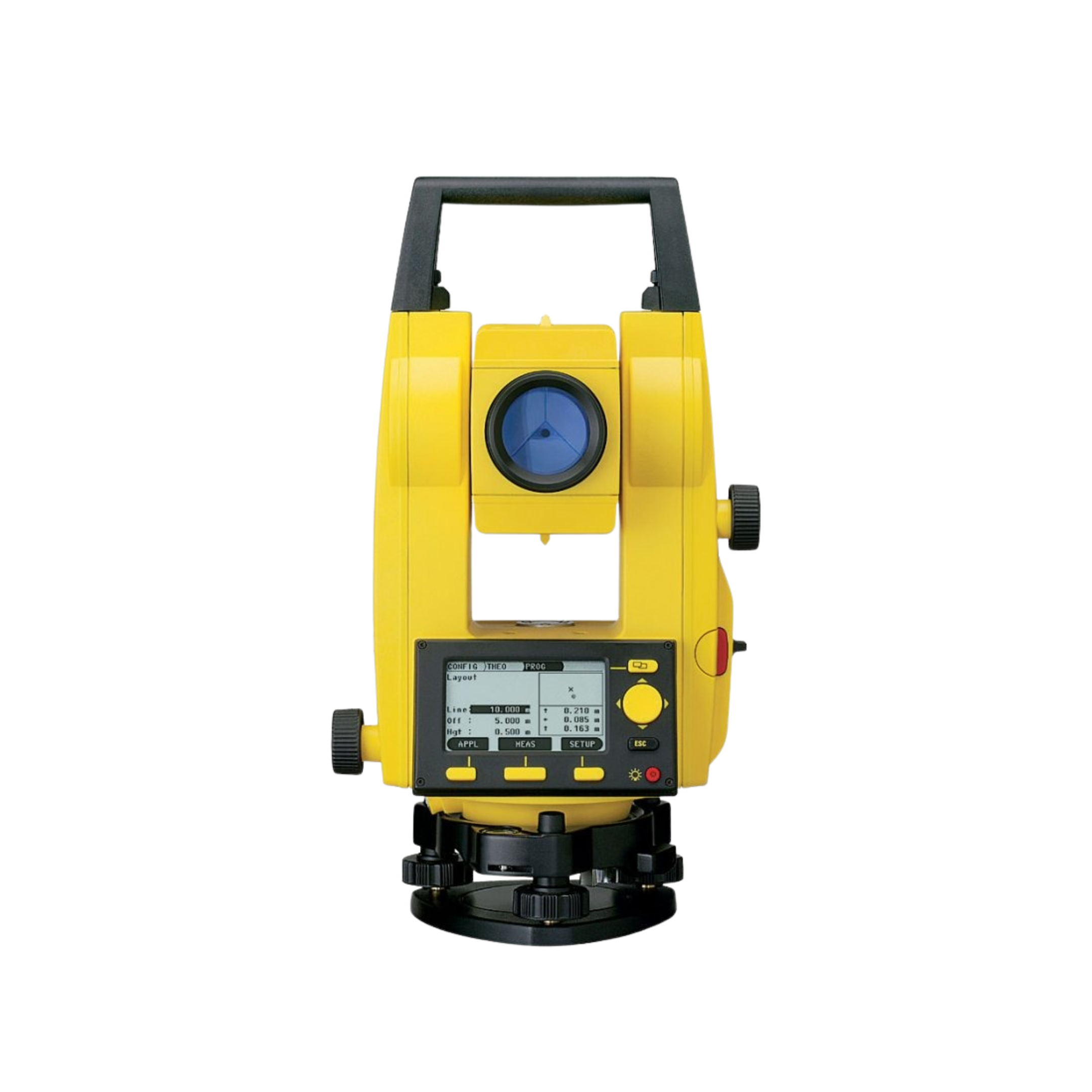
Leica Builder Series Total Station
The Leica Builder Series is a professional-grade total station designed specifically for construction and site layout tasks. Known for its precision, durability, and ease of use, it empowers construction crews to perform accurate measurements, layout, and alignment work without needing advanced surveying expertise.
🔹 Key Features
- High Measurement Accuracy: Delivers precise angle and distance readings for reliable layout and positioning.
- Reflectorless Technology: Measures distances without the need for a prism, ideal for inaccessible or hazardous points.
- Intuitive User Interface: Simple menu navigation and clear display make it easy to operate, even for non-surveyors.
- Robust & Weather-Resistant: Built to endure tough job site conditions with a rugged, weatherproof housing.
- Versatile Functionality: Supports layout, alignment, volume calculation, and basic surveying tasks.
- Data Connectivity: USB and Bluetooth options for fast and secure data transfer to external devices.
- Long Battery Life: Designed for extended field use with rechargeable batteries.
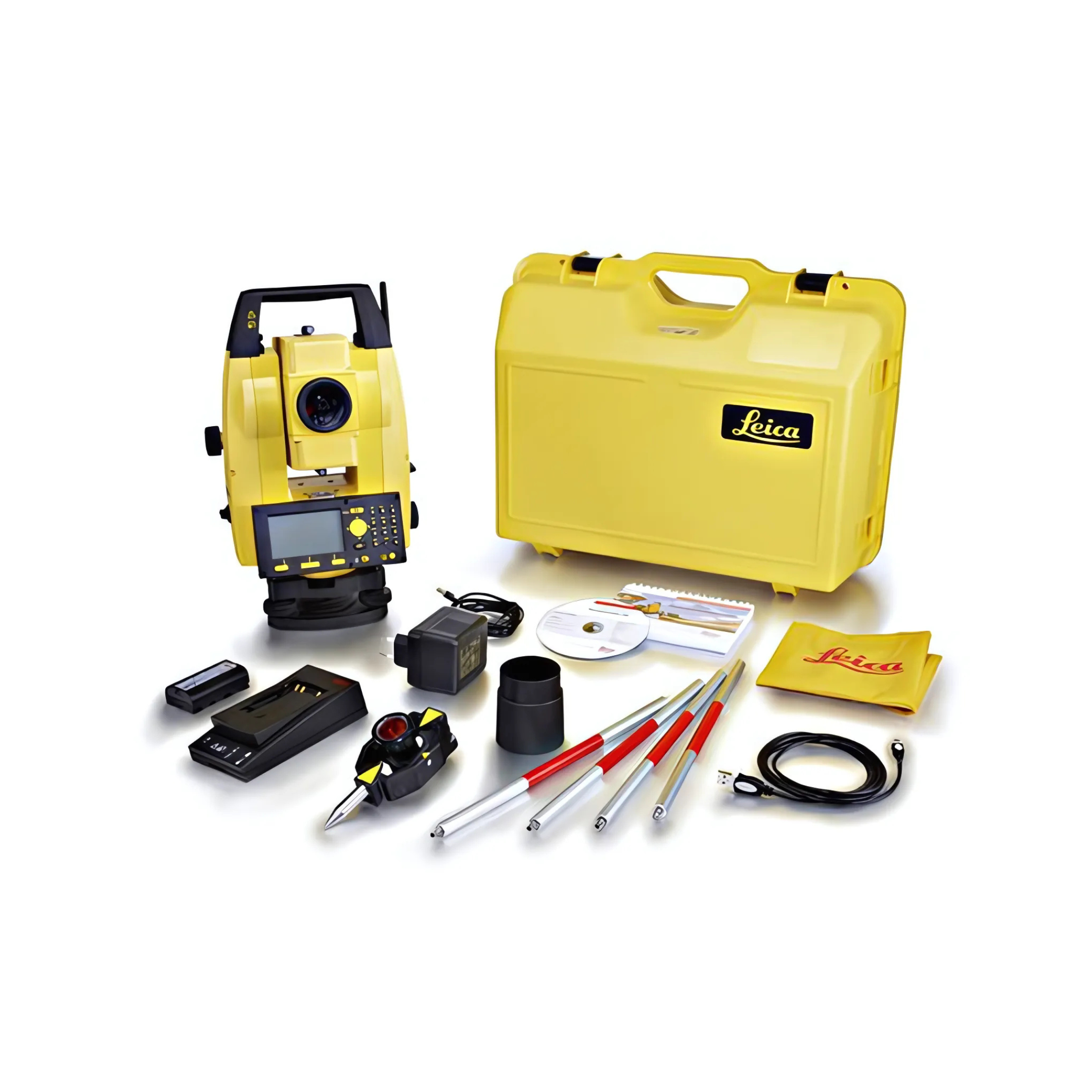
- Comprehensive Accessory Kit:
- Carrying case
- Battery charger
- Data cables
- Software CD
- Cleaning cloth
- Target poles
- Plumb bob holder
- User manual and setup tools
Reviews (0)
Brands


Related products


GPS HI TARGET V300/VRTK2
- GNSS Channels: 1400+ for enhanced signal tracking and reliability
- Satellite Support: Compatible with 50+ satellite systems including GPS, GLONASS, Galileo, BeiDou, and more
- Positioning Accuracy: High-precision RTK and static measurements (exact values depend on model)
- Battery Life: Long-lasting battery for extended field operations
- Connectivity: Supports USB, Bluetooth, and wireless data transfer
- Design: Rugged, weather-resistant casing for tough job site conditions
- Data Storage: Internal memory with support for external storage options
- User Interface: Intuitive controls and display for easy operation
- Software Compatibility: Works with major surveying and GIS software platforms
- Startup Time: Fast satellite acquisition and fix times for efficient workflow


HI TARGET GPS VRTK2
- Dual Cameras: Enables image-based surveying and live visual stakeout for rodless measurements.
- Tilt Compensation: High-precision IMU with auto attitude correction; accurate even when tilted up to 30°.
- RTK Accuracy:
- Horizontal: ±(8 + 1 ppm) mm
- Vertical: ±(15 + 1 ppm) mm
- Fast Initialization: RTK fix in under 10 seconds with >99.99% reliability.
- Built-in UHF Radio: Adjustable power (0.5W/1W/2W) for flexible base-rover setups.
- Smart Connectivity: 4G LTE, Wi-Fi, Bluetooth 4.2, USB Type-C, and NFC.
- Internal Storage: 8GB memory supporting GNS and RINEX formats.
- Rugged & Lightweight: IP68-rated, drop-resistant up to 2m, weighs ≤0.82 kg.
- Long Battery Life: 6800mAh battery provides over 10 hours of field operation.
- Smart Features: WebUI, voice prompts, remote cloud services, and smart base station support.
- Wide Operating Range: Functions reliably from -30°C to +70°C.


LEICA AUTO LEVEL
- High-Precision Optics: Delivers sharp, clear images for accurate readings over long distances.
- Automatic Compensator: Maintains a stable line of sight by correcting for slight tilts, ensuring consistent accuracy.
- Easy Focusing: Smooth and responsive focusing knobs for quick target acquisition.
- Sturdy Base: Equipped with three leveling screws for secure and stable setup.
- Built-In Bubble Level: Assists in precise leveling during instrument setup.
- Durable Construction: Rugged housing designed to withstand tough job site conditions.
- Compact & Portable: Lightweight design for easy transport and setup.


MERIDIAN GPS M20
- Green Laser Technology: Integrated laser with a 100-meter range for rodless, visual alignment in challenging environments like riverbanks, bridges, and indoor-outdoor transitions.
- IMU Tilt Compensation: 120° calibration-free IMU allows for fast, accurate data collection without leveling the pole.
- Long-Distance Capability: GSM mode supports communication up to 45–50 km, with an effective working radius of 15 km, ideal for large-scale surveying projects.
- Compact & Rugged Design: Palm-sized (699g), IP67-rated for dust and water resistance, suitable for harsh field conditions.
- Extended Battery Life: Equipped with a 7.4V 7000mAh lithium-ion battery, offering up to 26 hours of continuous operation.
- Connectivity: Bluetooth, 4G, and GSM for seamless data transfer and remote operation.
- Applications: Perfect for topographic mapping, construction site alignment, precision agriculture, municipal surveying, and infrastructure monitoring.


NIKON AUTO LEVEL
- 22x Magnification: Provides clear and sharp visuals for precise long-distance measurements.
- ±2.0 mm Accuracy: Ensures reliable results over 1 km double-run leveling.
- Magnetic-Dampened Compensator: Automatically adjusts for slight tilts, maintaining a stable line of sight.
- 360° Horizontal Circle: Facilitates easy and accurate angle measurements.
- Water-Resistant Construction: Durable design suitable for outdoor and harsh environments.
- User-Friendly Controls:
- Large focusing knob for quick target acquisition
- Fine horizontal adjustment knobs on both sides
- Easy-to-read circular bubble for leveling


NIKON TOTAL STATION
- Measurement Range: Long-range EDM for precise distance readings
- Angle Accuracy: High-precision angular measurements (model-dependent)
- Battery Life: Extended operation for full-day fieldwork
- Data Storage: Internal memory with support for external data transfer
- Connectivity: USB port for fast and secure data exchange
- User Interface: Intuitive menu system with easy-to-navigate controls
- Build Quality: Rugged and weather-resistant design for tough environments
- Applications: Suitable for topographic surveys, construction layout, and monitoring
- Optical System: Nikon’s advanced optics for clear and accurate targeting
- Display: High-resolution screen for clear data visualization


SOKKIA DIGITAL AUTO LEVEL
- Digital Display: Offers clear, easy-to-read measurements, reducing human error and improving speed.
- Automatic Leveling: Built-in compensator ensures quick setup and consistent accuracy even on uneven surfaces.
- User-Friendly Controls: Simple interface with intuitive buttons for fast operation.
- High Accuracy: Delivers precise leveling results essential for critical construction and surveying tasks.
- Durable Build: Rugged design built to withstand tough job site environments.
- Compact & Portable: Lightweight and easy to carry, ideal for mobile fieldwork.
- Reliable Performance: Consistent results across various environmental conditions

TRIMBLE R8S GPS
- Multi-Constellation GPS Tracking: Supports GPS, GLONASS, Galileo, BeiDou, and QZSS for enhanced satellite coverage and reliability.
- Scalable Configuration Options: Allows users to purchase only the features they need and upgrade later as requirements grow.
- Centimeter-Level RTK Accuracy: Delivers high-precision positioning for demanding survey tasks.
- Integrated UHF Radio: Enables base-rover communication without external radios.
- Internal Cellular Modem (Optional): Supports real-time corrections via internet-based services.
- Trimble Access Compatibility: Seamless integration with Trimble field software for efficient workflows.
- Web-Based Interface: Remote configuration and monitoring via browser-based tools.
- Rugged Design: IP67-rated for dust and water resistance; built to withstand harsh environments.
- Hot-Swappable Batteries: Continuous operation without downtime during battery changes.
- Advanced Signal Processing: Enhanced multipath rejection and signal tracking in challenging environments.
- Compact & Lightweight: Easy to transport and mount, ideal for field mobility.
Reviews
There are no reviews yet.